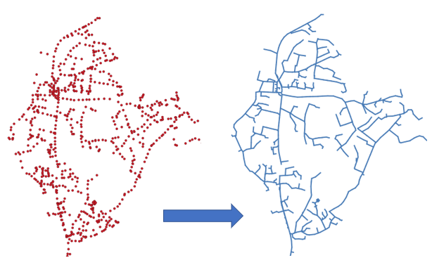
As for buildings, roads, and bridges, urban nature requires regular inspections, including an active monitoring of the health status of trees composing it. Several methods of analysis of the state of development of urban trees exist: Crown-Condition Classification in the United States [Schomaker et al. 2007], DEPEFEU in France [Nageleisen 1996], CROCO in Japan [Mizoue 2002], etc. However these methods deeply rely on the observer’s subjectivity, which weaken their results.

Regulation of emission of greenhouse gases

Protection from violent winds, heat waves, floods

Reduction of energy consumption

Improvement of individuals’ well-being and social bonds

Improvement of quality of the air, water and soil
In this work, we propose an approach that relies on visual methods of analysis along with technological features provided by mobile devices. We provide a set of guidelines for the implementation of a mobile tool that assists the observer during the analysis of the tree, without replacing his expertise. Our method aims to reduce excessive variations between observations of trees, while being performed without the need of multiple traditional tools (e.g. notebooks, pens, binoculars, tape measures) and providing access to knowledge that is unavailable today in the field (e.g. history of previous observations, data about other trees and interventions nearby, etc.).

Monitoring of the Health Status Of Trees
Several methods: Crown-Condition Classification, DEPEFEU, CROCO…
Very subjective, deeply rely on the observer
Our proposition:
- Set of guidelines for the implementation of a mobile tool
- Assists the observer without replacing its expertise
Objectives:
- Less variation between observations
- No need of multiple tools
- Access to knowledge unavailable today
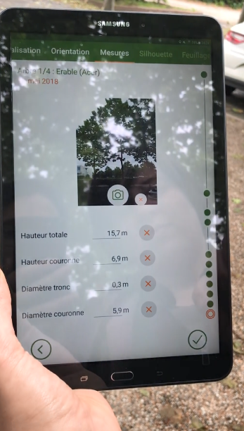
Discover TreeTech. In action
We implemented the method as a mobile application specifically designed to diagnose trees’ health. In addition of supporting the method, the mobile technology enables the use of sensors available on the device, such as GPS to locate the tree, magnetic field to choose a point of view to observe the tree, and camera to take a picture and measure the dimensions of the tree. A lot of data can be automatically collected on the field, thus reducing the cognitive overload of users. Furthermore, each step’s user interface has been designed to allow quick access and copy of data from previous observations on the same tree.
We perform regular ergonomic audits along the way and plan to validate our ambition to quicken and make the analysis easier by carrying out user tests with experts.

Location

Orientation and distance

Photo and measurements (telemetry)

Shape of the foliage

Densities of foliage

Additional observations (shoots, mortality)

Observation history: Timeline component on each screen
- Can be browsed: shows the same graphical interface but at the selected date
- Most data can be copied in the current observation (measurements, shape, densities of foliage, etc.)
- Allows quick access and copy of earlier data during the observation